THE 2020 NARGS Annual General Meeting will take place in Ithaca, which is at the head of Cayuga Lake, the second largest of New York’s Finger Lakes. The Finger Lakes are a group of 11 long, narrow lakes created by glaciation, and they are a geologically unique area. This area is also noted for spectacular scenery, and thanks to those climate moderating lakes, it is New York’s premier wine-growing region. This article explains, in simplified terms, why there are Finger Lakes and other interesting aspects of our local geology. Understanding how our scenery was created makes my travel through the area more interesting.
Approximately 550 million years ago much of New York State subsided (sank) and was covered by the sea for 325 million years. Through erosion, material including sand and gravel washed down from higher lands to the north and east, the Adirondacks and New England. Conditions throughout this time were not uniform, and thick salt beds accumulated from evaporating seawater in some areas in the region. There is a salt mine here deep below Cayuga Lake. Sand, mud, lime, and salt kept accumulating and the sea bottom likely continued to subside allowing long term accumulation of material. The bottom layers hardened to became limestone (calcium carbonate), shale (from mud or clay), and sandstone (from sand). These sedimentary layers are around 8000 feet (2.4 km) thick in the Finger Lakes region.
Around 200 million years ago there was an uplift, which caused a rise in the elevation of the Finger Lakes. The slope of the rock beds, toward the south, was maintained during the uplift. The sedimentary beds rose to a height thousands of feet above sea level and the streams draining the area became the Susquehanna River and its tributaries. Erosion wore down the land to near sea level for around 100 million years before a second uplift raised the height of the land, including the height of the drainage divide between the north-flowing and south-flowing streams. Weak beds of rock, like shale, were very thick in the Finger Lakes area, allowing streams to wear down the land surface to a relatively low level. Still, the undulating highlands around the southern ends of the Finger Lakes are currently at an elevation of up to around 2,200 feet (670 m) above sea level.
Around a million years ago, ice began to accumulate on the Labrador Plateau (high country in Quebec and Labrador), building up to around 10,000 feet (3,000 m) thick. The ice spread laterally over the Finger Lakes area, eventually reaching Williamsport, Pennsylvania, over 100 miles (160 km) south of Ithaca. The ice in Central New York was over 2,500 feet (762 m) thick. The glacier may have moved only a few feet per day, but it was an unyielding mass of ice moving continuously for many years, generally in a southward direction. The ice gathered rocks which gave it tremendous power to erode the surface of the land. The low land in Central New York was an easier path for the glacier to follow in its continuing southward journey. The erosive power of the ice was greatest in the north-south running valleys, which include the Finger Lakes. As the ice moved southward, it was constricted by narrower valleys, forcing it to flow more quickly in those narrow areas. The eastern Finger Lakes (Otisco, Skaneateles, Owasco, Cayuga, and Seneca) were thus created by those narrow channels.
There was a glacier-free interval after the first glaciation followed by a second glaciation. The major effect of the second glaciation was to leave tons of glacial debris behind; perhaps the most obvious are terminal moraines (deposits of sand and gravel dumped when the ice front remained stable over a 100 to 200 year period), for example at Tully, Onondaga County, New York, just east of the Finger Lakes. Another artifact of glaciation is kettle ponds, which were created by ice blocks left in glacial debris. The ice eventually melted and filled the pits with water. Tully, New York, is the site of several kettle ponds. Donna Kraft’s garden (one of the gardens on the pre-meeting garden tour) is on Crooked Lake in Tully, one of those kettle ponds.
Through valleys are yet another glacial artifact in the Finger Lakes area. These are flat, glacial valleys connecting the north-flowing drainage (streams that flow into Lake Ontario and the St. Lawrence) and south-flowing drainage (streams that flow into the Susquehanna River) without passing over any high land. Glacially carved valleys typically have relatively flat bottoms and oversteepened sides due to the ice scouring out the sides of the valley; this valley shape is common in this Lakes area. Though there is no igneous bedrock (e.g., granite or gneiss) anywhere near the Finger Lakes, glacial erratics (igneous rocks, which could be cobbles or large boulders) are common in the area, carried by glaciers from distant points, likely the Adirondack Mountains or Quebec.
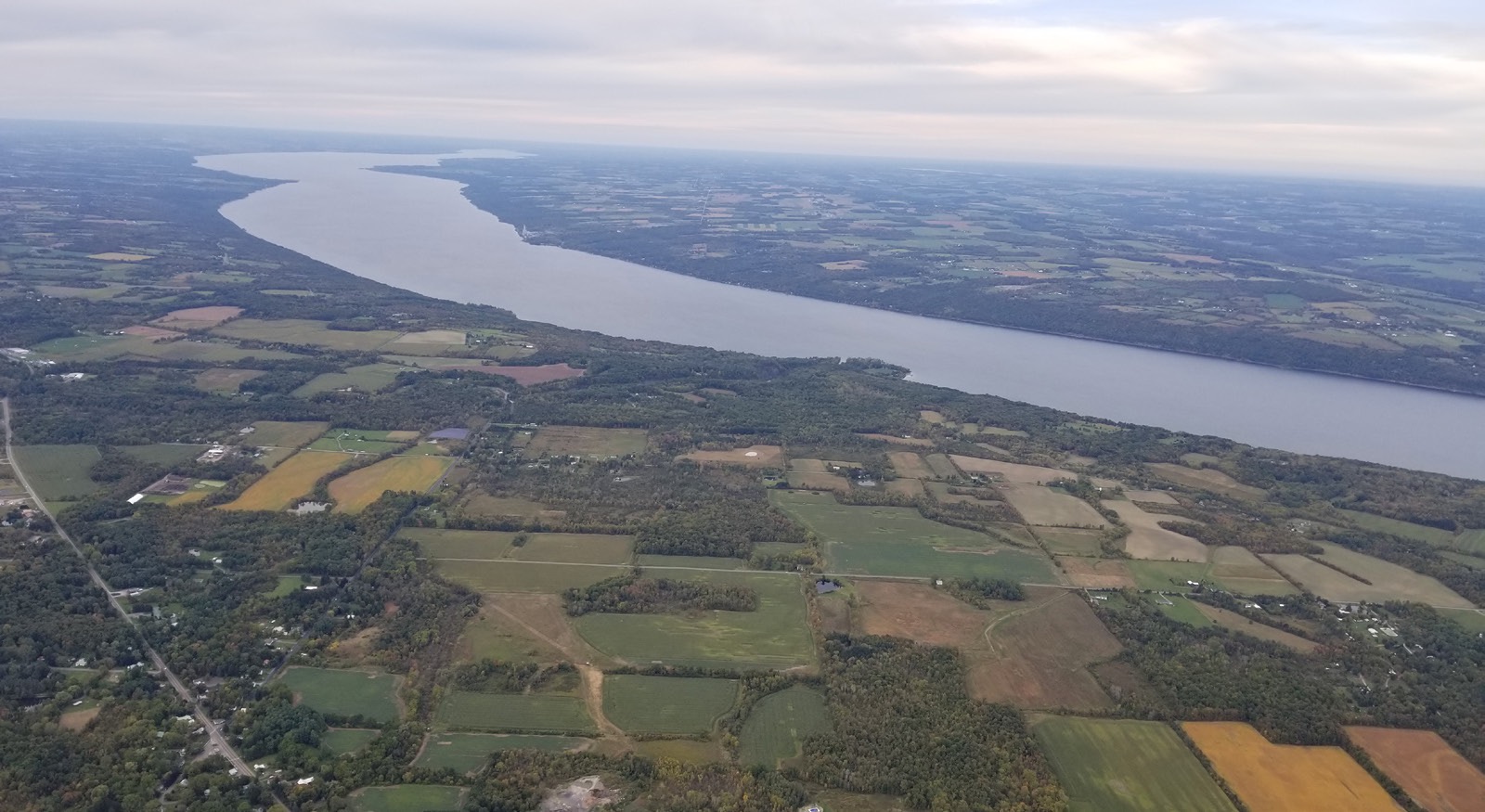
The depth of the two largest Finger Lakes, how deeply they were scoured out by ice, illustrates the power of glaciers. Cayuga Lake is approximately 40 miles (64 km) long, 3.5 miles (5.6 km) wide, and 435 feet (132 m) deep (around 50 feet (15 m) below sea level). Seneca Lake is 38 miles (61 km) long, 3 miles (4.8 km) wide, and 618 feet (188 m) deep (that’s 174 feet, 53 m below sea level) and is New York’s deepest lake.
The glaciers receded from New York State for the last time between 9,000 and 10,000 years ago. Since the ice left, streams tumbling down off the higher elevation uplands to Cayuga Lake carved through thick shale beds, creating the dramatic gorges for which Ithaca is known. Among the gorges are Buttermilk Falls (a state park), Enfield Glen (in Robert H. Treman State Park), Taughannock Falls (a state park), and Cascadilla Gorge (managed by Cornell Botanic Gardens, subject of a talk during the meeting by Sarah Fiorello of Cornell Botanic Garden). Cascadilla Gorge, which has a trail you can hike, drops 400 feet (122 m) through sedimentary rock layers from Cornell to downtown Ithaca. The field trip during the meeting will include a walk in the gorges of either Buttermilk Falls or Enfield Glen. Buttermilk Falls State Park is unusual, in that the rocky gorge environment in the park has neutral to alkaline growing conditions, and some of the upper areas of the park above the gorge have acid growing conditions, with ericaceous plants. Taughannock Falls (pictured on the front cover) is one of the highest waterfalls in the eastern United States, with a vertical drop of 215 feet (65.5 m). The gorges and waterfalls would not have been as impressive if it were not for the glaciers heavily scouring out the Cayuga Lake valley. Though plants are challenged to grow in the crumbly shale bedrock of the gorges, we should see the lovely fern Asplenium trichomanes, maidenhair spleenwort (which is also the fern in the AGM logo) growing in the gorge walls.
Should you wish to extend your stay beyond the meeting activities, there are many more natural wonders to take in around Ithaca.
The source of the information in this article is The Finger Lakes Region, Itxs Origin and Nature, by O. D. von Engeln, Cornell University Press, 1961.